This is day one of my three-day adventure into the Horseshoe Canyon-Maze area of Canyonlands.
The trip didn't start out too great. It would get better...
It was April 15, and I had driven several hours over bone-rattling washboard of the San Rafael Desert, fast approaching the boundary of the Glen Canyon National Recreation Area. Since I had to be at the Hans Flat ranger station first thing in the morning, I needed to find a place to throw down my bedroll as close as possible to the RA boundary, but not beyond where a camping permit from the NPS is mandatory. My GPS indicated I was within a few 100 yards of the boundary when I finally spotted a dirt road splitting off to the south that looked like it led to a primitive camping area. I turned and passed one small outfit camped in a clump of juniper trees, but the road continued a bit farther to a pleasing, small flat.
Not wanting to waste another minute of sleep time, I immediately unfurled my sleeping bag and was about to crawl in when I noticed a headlamp bobbing toward me. I was expecting perhaps an invite to share a beer and tall tells around the campfire, but what I got was a stern, yet fairly polite request to pack up and camp somewhere else. Apparently, I was too close for comfort and had ruined someone's wilderness experience. Seemed to me I was a reasonable distance away. Since he kept addressing me with "you guys," I though if I explained it was just me, and there would be zero noise, no fire, and I'd be gone before the sun came up, he'd be satisfied. He was unconvinced. I was deliriously tired, and I don't recall everything said, but I do recall the guy saying something about it being
a free country and I can camp where I want to, but I really should yadda, yadda, yadda... I chose freedom and stayed put. I had more than one dream that night of being picked to death with a tent stake.
The rangers at Hans Flat walk over from their sleeping quarters to the ranger station at about 20 minutes to 8 AM. The first ranger, an older gentleman, tapped on my window and said I could come in once the American flag was raised. He also wanted to know my plans so he could start checking permit availability. I explained that I needed a permit for that night as close to the top of the Golden Stairs as possible. At the crack of dawn, I would then pack my disassembled mountain bike down the short (< 2 miles) but steep Golden Stairs trail to the Dollhouse 4X4 road. Then I'd reassemble my bike, ride a short distance to the unmarked and seldom-visited Ernie's Country trail head and run to the "cedar bark" ruin (Anasazi granary), Lou's Spring, and into the most photogenic parts of The Fins in Sand Tank Canyon. From there, I'd backtrack to my bike and continue cycling down the 4X4 road to either the Standing Rock or Chimney Rock campsite. From there, I would then venture into the heart of the Maze by hiking to the Chocolate Drops, Maze Overlook, and the Harvest Scene pictographs. The second day in the Maze would be a quick trip to check out the Doll House area.
Although the ranger worried I was trying to cover too much ground, he seemed content with my plan, and shuffled into the station. A couple of other rangers soon arrived. A much younger ranger, clean-shaven with a freshly ironed uniform, polished boots, and a new shiny badge approached. This guy worried me. He also inquired of my plans. I got as far as explaining my plan to pack my bike down the Golden Stairs, when the young ranger, who clearly has his sights set on being Park Superintendent, stopped me. "You can't take a bike down that trail," he said.
Thinking that perhaps he misunderstood me, I reiterated that the bike would have its wheels removed and everything would be attached to my backpack and stressed that bike wheels would never even touch the trail. It didn't matter. "No mechanized form of travel," he said.
"A disassembled bicycle is a form of travel?" I asked.
He wouldn't discuss it further. Whatever. After more than 3 years of dreaming and over a year of planning every detail, I didn't like the thought of last second changes.
Sensing my frustration, the ranger assured me that we could come up with an alternative plan to get me into the Maze. I had already analyzed every other alternative. There was not a quicker or more efficient way for me and my bike to get into the Maze. I knew whatever the ranger had in mind, it would take longer and something would have to be cut from my itinerary.
Once I got into the ranger station and we started looking at available campsites, we hatched the plan to have me drive down the Flint Trail to Water Hole Flat and then on to the Teapot Rock campsite. That's as far as stock SUVs without lifts and ruggedized tires can go. What this boiled down to was, instead of a quick and easy hike down the Golden Stairs, I now had an elongated mountain bike ride through the most difficult part of the Dollhouse 4X4 road across the rim of Tea Pot Canyon--no walk in the park with a 40 pound backpack on. Not to mention I didn't have chamois(!) nor had I overinflated my bike tires and shocks to help negotiate the ledgy trail with the extra weight. Not a perfect plan but it would have to do.
With my revised Maze plans squared away and permits in hand, I was ready to attack the day at hand. First up: Blue John Canyon.
Made famous by Aaron Ralston and his unfortunate 2003 mishap that left him one hand short, Blue John Canyon reached infamous status after Danny Boyle's
127 Hours movie.
To maximize time, and to lessen backtracking, I stashed my bike at the "direct route" trail head near the top of Main Fork, drove to the West Fork trail head, and descended West Fork to the lower slot in Main Fork where Ralston got stuck. I'll let the photos tell the story from here:
 |
| Nice slot near the top of West Fork of Blue John Canyon. Nothing technical here. |
 |
| Below an initial slot section, West Fork gradually opens and deepens. From here to the confluence with Main Fork and on to the lower slot it's pretty much a sand slog. It's much more efficient to run the sandy sections. It took just over an hour to get to the lower slot. |
 |
| The "s-log" marks the unmistakable entrance to the lower slot of Blue John Canyon. This should be an easy downclimb for most. |
 |
A simple stem maneuver just upstream of the "s-log" gets you down into the lower slot.
|
 |
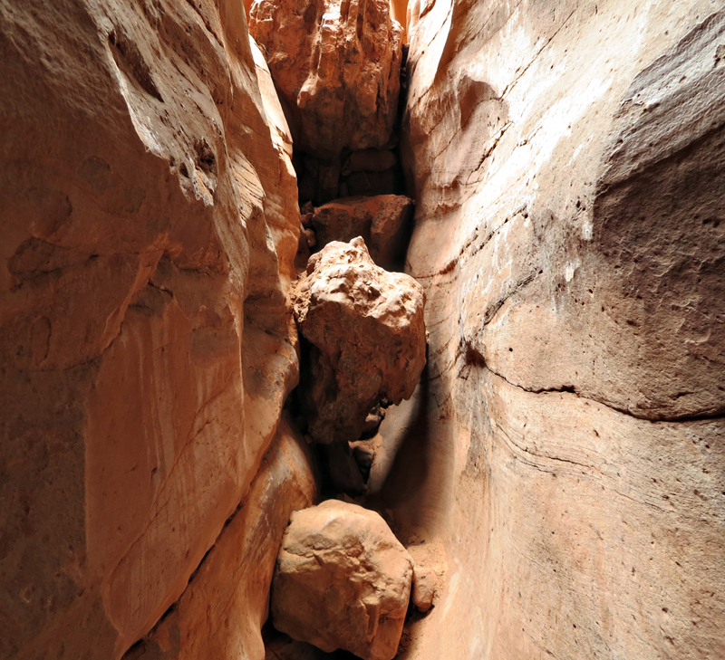
| Ducking under boulders in "The Gauntlet" of lower Blue John Canyon. |
 |
| The smaller boulder below the big boulder I'm standing on here is the "Ralston rock". This is essentially what Aron saw just before he and the boulder he had been standing on tumbled down, resulting in his hand being pinned against the canyon wall. |
 |
Looking back upcanyon at the "Ralston rock" (in the photo center). There is some disagreement about whether Ralston's boulder actually remains. One guy I met in the canyon insisted it is now buried beneath the canyon floor. It sure looks like the same rock to me (compare with photos below).
|
 |
| A self-shot by Aron after being stuck for nearly 5 days. I'm confident this is the same boulder as shown in the photo above. The boulder was rotated counterclockwise and dropped farther down into the slot after Aron's hand was removed by park rangers (below). |
 |
| NPS photo of the "Ral-Stone" immediately after park rangers used a winch and hydraulic jack to help remove Aron's forearm and hand. The remains were cremated and returned to Aron, who later returned to Blue John Canyon to spread the ashes where he said they belong. |
 |
Below the Ralston rock, the slot becomes increasingly convoluted and dark.
|
 |
| The deepest, darkest part of the lower slot of Blue John Canyon. Even though I passed through at midday, it was almost dark enough to require a headlamp. I've read several reports of rattlesnakes in this area, although I saw none on my trip. |
 |
| It only takes a few minutes to pass through the lower slot, but plan on taking longer if you want pictures. A tripod is practically mandatory in the low light. |
 |
The lower slot ends at a 60-foot pour-off above lower Blue John. Rappelling gear is necessary to descend the dryfall, then it's a couple of miles to Horseshoe Canyon (where Aron was ultimately rescued). This is where I turned around and retreated back up the Main Fork, essentially reversing Aron's route.
|
 |
| At the bottom of the drop is this stagnant pool Aron rappelled into (with one hand, and on the brink of death) and drank from toward the end of his ordeal. The water Aron drank likely looked similar to this, except he mentioned there was a dead raven floating in it. |
 |
| I bypassed the West Fork and kept running up the sandy Main Fork of Blue John Canyon. |
 |
| Farther up the Main Fork, the walls close in and form an impressively deep slot. |
 |
| Main Fork Blue John Canyon. |
 |
The deepest part of Main Fork is an easy walk-through canyon.
|
 |
| Upcanyon from this point, the Main Fork becomes a challenge. I passed two groups descending this semi-technical section with ropes, helmets, and the whole get-up. The slot is narrow enough to where if you're experienced with various techniques using your body as a wedge, it's possible to climb without ropes. (no pics in the semi-tech section since I had my camera stashed safely in my pack). |
 |
| Looking down into the semi-technical section of the upper Main Fork of Blue John Canyon. Although this section is only a couple of hundred feet long, it may take close to an hour to squeeze through. |
 |
| Upper Main Fork before it slots up. |
 |
| On the "direct route" from the top of the Main Fork upper slot. Navajo Sandstone here exhibits differing oxidation states (red vs. white) of included iron minerals. |
Returning to the Montero in the afternoon, I had just enough daylight left to hit Horseshoe Canyon--the detached, remote section of Canyonlands National Park known for its distinctive pictographs.
With the sun getting low and storm clouds approaching from the east, I knew I'd have to knock off the 8-mile Horseshoe Canyon trail in a hurry.
 |
| Gray clouds threaten over Horseshoe Canyon. |
 |
| The High Gallery is the first panel encountered once you're down on the canyon floor. It's also the only panel on the east side of the canyon. |
 |
| A short distance from High Gallery is Horseshoe Gallery. The rock art in Horseshoe Canyon is the type locality for Barrier-style rock art (named after Barrier Creek in the bottom of Horseshoe Canyon which almost always has at least a small flow) found scattered in other places in the southwest. The panels in Horseshoe Canyon are thought to predate the Anasazi and are more than 2000 years old. |
 |
| Horseshoe Gallery. |
 |
| Alcove Gallery. Sadly, this panel has been badly defaced over the years. |
 |
| At Alcove Panel, looking out of the alcove into Horseshoe Canyon. |
 |
| The Great Gallery. The second most interesting pictograph panel on the Colorado Plateau in my book (that I've personally visited) behind Shaman's Gallery in Grand Canyon. |
 |
| Great Gallery. |
 |
| Great Galley. |
 |
Life-sized ghosts of the Great Galley.
|
After running through Horseshoe Canyon in about 2.5 hours, I had a fairly long and bumpy ride ahead to get to my designated campsite for the night at Teapot Rock.
The road south of Hans Flat skirts the 1000-foot-high Orange Cliffs and offers periodic views toward the "Under the Ledge" country below. I timed my passage through here nicely, with the last rays of daylight setting the desert on fire.
 |
Millard Canyon Overlook from atop the Orange Cliffs.
|
 |
| Cleopatra's Chair rests high above Millard Canyon. |
 |
| Another view from Millard Canyon Overlook. |
 |
The Orange Cliffs and Elaterite Basin at dusk.
|
 |
| Bagpipe Butte. |
 |
| Flint Trail Overlook. The Flint Trail is generally too narrow for two-way traffic. It's mandatory to scout out the trail to make sure no one is heading up at the same time. |
I rolled into Teapot camp at about 10:30 PM.
Dang tired, but a little giddy about everything I'd finally be seeing in the morning, I fell fast asleep on the slickrock.


I'll be the first to donate $10 to the new show foundation for Cedar and Sand. Never leave home without your duct tape!
ReplyDeleteThe boulder you photograph with the caption that says someone told you the actual boulder that pinned Aron's arm could be buried - that comment is false. That is the same boulder that pinned his hand. It's been raised and turned counterclockwise 1/4 of a turn and wedged a bit lower and to the north of where it pinned his hand (sideways it's more narrow) - I've mapped the topography of the photos of it Ralston took during the ordeal to photos I took up close and it's the same rock. Matthew Wittmer, April 2014 http://stormbound.org/bluejohn.html
ReplyDelete