
The Trans-Zion is a 48-mile route across Zion National Park that wanders from the East Entrance to Lee Pass in the Kolob Canyons section of the park. The route links together many of Zion's most scenic trails and amasses more than 10,000 feet of total climbing.
The trail is typically accomplished as a 4-6 day backpack, but elite long-distance trail runners have adopted it into their list of must-do single-day runs. And, to cover that distance in a single day, you really must run at least a large part of it.
I've always wondered what it would be like to cover that distance sans a bike. I knew I had a sufficient motor, but, could my legs handle the pounding?
You see, I'm not a runner. It has never really appealed to me, and I don't think I've ever ran non-stop for more than 8 or 9 miles before. A five mile run on the road around the neighborhood is torture -- utterly boring much like riding a stationary bike. If you've followed this blog at all, you also know that I'm no couch potato either. I can ride the wheels off a mountain bike and I've done plenty of long and grueling hikes, but could my body's physiology -- my muscles, tendons, etc. -- conditioned for cycling and hiking -- hold up to nearly 50 miles of nonstop trail running?

After a 3 am start and 1.5 hour drive to the East Entrance, I hit the trail just as the sun was coming up. An early start allowed me to see the final stages of a full lunar eclipse, although by the time I took the photo above it was just about over.
The trail gains about 1200 feet in 4 miles as it follows Clear Creek, crosses Jolley Gulch, and finally tops out on the White Cliffs plateau. Once on top, it was obvious I was going to be in for a treat with the wildflowers at their absolute peak in the high country.

My plan was to run the flats and downhills and power-hike the uphills.

After passing Stave Spring and crossing a grassy meadow, the trail begins its descent down Echo Canyon. The descent is gradual at first and then becomes an all-out free-fall, dropping more than 1000 feet per mile.
Near the fork with the Observation Point trail, about 9 miles in, I encountered for the first time another hiker.

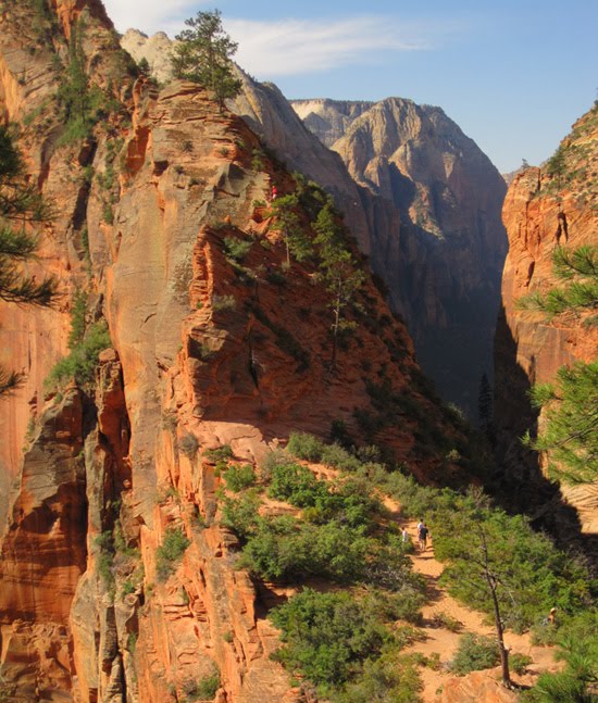
Having never explored this portion of Zion, I delighted in the immense views of Echo Canyon that the East Rim trail offers. I was much less delighted in the fact that the trail is literally paved with cement for several miles -- the hard surface led to a few minor hot points in my knees as I kept up a fast pace.


Above: looking down on the steep, paved switchbacks of the East Rim trail near the mouth of Echo Canyon.

It was still early morning by the time I reached the main canyon near Weeping Rock (about 11 miles in). After jogging down the requisite single mile of pavement, I refilled my Camelbak at a spigot in the Grotto picnic area. As I fueled up, I watched bus-loads of tourists unload at the West Rim trailhead heading for Angel's Landing and I knew it was going to take some extra energy to bob, weave, and pass through the slow moving crowds.

Above: looking up Zion Canyon from the start of the West Rim trail. Angel's landing is the high mesa on the left.

Above: looking down Zion Canyon from near the mouth of Refrigerator Canyon, partway up the trail toward Angel's Landing.

Above: "Walter's Wiggles," a steep, zig-zagging trail built to make the climb out of Refrigerator doable for the average tourist.
The Trans-Zion route took me across many a trail I'd never hiked, but my tight time constraints didn't allow me to make the 1 mile out-and-back detour to Angel's Landing -- one more thing I still have to look forward to completing someday.
Above: from near Scout Lookout, you can see the first part of the trail climbing the narrow and exposed fin up to Angel's Landing.
While the hike to Angel's Landing is generally considered a grueling hike, it really is only a warm-up (about 1300 vertical feet) before topping out on top of the West Rim (over 3000 vertical feet).
The climb out of the main Zion Canyon (either the East or West rims) is by far the toughest part of the Trans-Zion. Completing the route from east to west as I did, gets the massive climb out of the low elevation (and therefore, hot) canyon over with in the morning hours rather than during the early evening heat, which is required if going west to east.

Above: from high on the West Rim looking down on the "The Organ" which towers over the "Big Bend" in the Virgin River.

Above: near the head of Telephone Canyon is a slickrock wonderland known as "Little Siberia." After a few hours of nonstop climbing to get to this point, it is still another 1000 feet to the top of the cliffs above Siberia.

Above: the final 1/2 mile of trail before reaching the top of Zion Canyon's rim consists of is this 3-foot-wide ledge blasted out of sheer walls of Navajo Sandstone, with a 500-foot drop-off to the side toward Telephone Canyon.
I reached Cabin Spring on the edge of the Horse Pasture Plateau around lunchtime, but goofed by not topping off my hydration bladder. I figured most of the climbing was behind me and that my remaining 1.5 liters of water would last until the next watering hole at Wildcat Spring.

Above: lush forests of Ponderosa pine cover the top of the Horse Pasture Plateau.

Above: the timing for cactus blooms couldn't have been any better.

I made good time along the West Rim trail as it gradually crawls up the plateau towards Lava Point. For long stretches through flat forests and meadows, it's easy to forget you're in Zion, which rarely is mentioned in the same sentence with the word flat. But there is no doubt where you are when the trail edges toward the rim, and you attempt to make sense of the unparalleled views across the some of the most extreme terrain on the planet -- canyons that only the most skilled technical canyoneers will ever venture into and mesa tops that still have not seen the footprints of Man.

Above: looking south into the deep ravines carved by the tributaries of Heaps Canyon.

Above: although I took a good map with me, I never touched it. Every junction is well signed.

Above: a small grove of aspen line the West Rim trail.

Above: looking west toward the Left Fork (a.k.a., the Subway) of Great West Canyon. Or is it the Right Fork? There are too many canyons to keep track of around here.


Above: at least one pioneering soul tried to farm the small meadow beneath Lava Point.
Late in the afternoon, I reached the turnoff for the Wildcat trail. Now past the halfway point, I still felt good and continued to run the majority of the time.

Above: Wildcat Canyon

Above: what? Purify spring water? There isn't a better water filter than good ol' Mother Earth. This was the best tasting water I've ever had. Just watch out for the poison ivy.
I ran out of water a good 2 or 3 miles before Wildcat Spring, which didn't seem to be a problem at first, but several hours later, I would pay dearly and never recovered from the deficit.
After several miles on the Wildcat trail, I forked left onto the short Connector trail that passes Pine Valley Peak and then drops into pretty Lee Valley.

Above: looking down into Lee Valley from the Connector trail.

Above: running (with some pretty wobbly wheels at this point) across Lee Valley with the Upper Kolob Plateau in the distance.
Almost 34 miles in, near where the Connector trail ends and the Hop Valley trail begins, the mileage began to take its toll. Joints were stiffening, heart rate was high, but most alarming was the fact that my stomach had completely shut down. My appetite was replaced with a sickening nausea, and I had to force myself to swallow small amounts of food and water that ultimately just sat, undigested, in my idle stomach.
This is not the first time I've had serious GI issues with long, hard efforts. I knew it would be hours -- time I didn't have -- of rest and vomiting before I could pull out of it and start ingesting water and calories. My only options were to give up, hitchhike down the Kolob Road to Virgin, and call Susie to the rescue; or, try and complete the last 14 miles on nothing but fumes in the tank.
Ignoring the nausea and some tendinitis flare-ups, I still felt pretty energetic, and I was confident that I could finish. It would hurt, but I could finish.
I soon doubted about my decision to forge on. I was banking on the first several miles of the Hop Valley Trail to be a nice gradual and effortless downhill jog. The first part is mostly downhill, but it's not exactly effortless due to the loose, energy-sucking sand. I was not mentally prepared for the sand slog, but just as I was going to crack, the trail firmed up and began a steeper rate of descent.

Above: looking north into Hop Valley.
Hop Valley ended up being the biggest surprise of the trip. This seldom-visited chunk of Zion is unreal. Here, a football field-wide grassy floor is bordered by tall Ponderosa pine that are backed by towering cliffs of crimson sandstone. There really is no trail, just skip through the knee-high grass and splash through the cool, clear meandering stream as you make your way northward through the amazingly straight, fault-aligned valley. Endorphins, triggered by the surprising beauty of the place took over as my calorie intake was reduced to zero. For a few golden miles through Hop Valley, I felt fantastic.


What really sets Hop Valley apart from other canyons in Zion is the fact that it has such a flat, wide bottom -- a big contrast to the claustrophobic widths of Zion's famous slot canyons. Why so flat? The answer lies in the lake deposits that are exposed in the bare stream cut in the above photo. Yeah, that's right, lake deposits. Several thousand years ago, a massive sandstone fin or alcove along the west side of the canyon near the confluence with LaVerkin Creek, catastrophically failed and created a natural dam that blocked the drainage out of Hop Valley for many years. This created a long and narrow lake that would have looked something like one of the narrower arms of Lake Powell, except it would have been lined with alpine vegetation -- it would have been something to behold. Eventually, the lake over-topped the dam and the rushing waters cut the deep chasm at the mouth of Hop Valley (the trail at the bottom of Hop V. avoids this chasm and climbs up and over the what remains of the gigantic rock dam). The lake drained, but several 10s of feet of silt, sand, and mud that settled out of the placid lake remain and still cover the narrower inner canyon.

With just a couple of hours of daylight left, I reached the end of Hop Valley and veered left down the La Verkin Creek Trail, which was now familiar ground having hiked here several weeks prior with a Scout group. I tried to ingest some fresh water out of Beatty Spring, but my stomach would have none of it. My guts cramped, and for the next couple of minutes, I was bent over, emptying my stomach through a series of loud reversals. In terror, I looked up to see some backpackers that had witnessed my disgusting display.
Well, you get the picture. I was real sick, but I somehow managed to continue on. To add insult to injury, aggressive and suicidal deer flies began attacking my legs as I hiked along the creek. I ultimately had to cut down a few small willows to whisk back and forth across the back of my legs as I walked similar to the action of a horse's tail.
After leaving La Verkin Creek, the biting flies went away but I still had to finish a 5 mile, 1000-vertical-foot climb ahead before arriving to my waiting car at Lee Pass.
The climb to Lee Pass was completely agonizing. I would have to stop every mile or so for a minute to try and muster up the energy to keep going on. Those last 5 miles, which were a breeze with the scouts, easily felt like 15.
48 miles and 16 hours after I'd begun the day's journey, I finally stumbled to my car, took a 15-minute power nap, and headed home.
My wife later explained that I looked like the walking dead, and believe me, I felt like it.
But I'm quick to forget the pain. If I can manage to up my trail-running mileage in the coming months, I'll seriously consider trying the similarly grueling 47-mile, 12,000-vertical Grand Canyon Rim-to-Rim-to-Rim run this fall. Hmmmm....we'll see how it goes.

Above: the last rays of daylight illuminate the north flank of Burnt Mountain near La Verkin Creek.
Awesome.
ReplyDeleteReally? You did this? Impressive.
ReplyDelete- M Bahr
I know, it's hard to believe, but it's no joke. I think I'm hooked on these long distance trail runs. Are you still running? How about joining me for grand canyon in the fall!?
ReplyDeletewow excellent trip with super photos
ReplyDeleteThanks. I'm really glad you liked the photos - they weren't easy to get. I don't know what I was thinking, it's completely idiotic to waste time taking timer-shots during something like this.
ReplyDeleteMagnificent run! Well done on having the guts and determination to finish it.
ReplyDeleteThat scenery is magnificent - what beautiful distractions from the pain in your legs.
Your run is awesome but I loved this report for the memories it brought back. I stopped in Zion, amongst other places, when returning from New Zealand. How you can take such phenomenal photos when on the limit is beyond me.
ReplyDeleteKeep up the great work,
John
Great story and awesome photos. I am going to give this a try in a couple weeks. I will be treating the water though....
ReplyDeleteI've always wanted to experience running through Zion National Park.
ReplyDelete