 |
| Mooney Falls. |
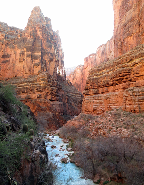
Few visitors to Havasu make the scenic 8-mile hike (16 mi round trip) from the campground to the Colorado River. I can't imagine why. As you proceed downstream, the canyon deepens and you see fewer and fewer tourists. All the while, Havasu Creek maintains its Caribbean-blue waters as it swirls through interlocked tubs and tumbles over grand staircases. And at the end of the trail, you find yourself at the very bottom of one of the greatest natural wonders of the world.
 |
| A creek crossing at Havasupai Campground. |
 |
| Several mines (sliver-lead, and later probably vanadium) can be found in the cliffs above Havasu Creek, particularly near the campground. Close to one of these mines, stood an old miner's cabin where author Edward Abbey stayed for 5 weeks sometime in the 1950s. His time spent at Havasu is chronicled in his book Desert Solitaire. |
The Havasupai Campground terminates to the south where the bottom of the canyon and Havasu Creek make a dramatic 200-foot drop at Mooney Falls. A precarious trail twists down a series of ledges and tunnels toward the base of the falls where heavy chains and a wooden ladder assist with the final near-vertical drop to the canyon floor.
According to the Supai, only spirits and birds traveled beyond Mooney Falls prior to the 1880s when adventurous miners began penetrating every nook and cranny of the Grand Canyon in search of precious metals.
The history of the waterfall's namesake is a bit murky. All accounts seem to agree that a prospector by the name of Mooney (some claim his first name was James, but apparently, mining records list a D.W. Mooney) fell to his death at these falls in 1882. All also agree that he was part of a larger mining exploration party consisting of several other prospectors. There is less agreement on the details about how exactly he died and where his remains were buried. Some claim he was being lowered down on a rope by his companions when the rope frayed on a sharp travertine curtain and broke, sending Mooney to his death. Another variation is that the rope jammed in a crevice, stranding him in a dangling position for three days before the rope suddenly snapped. Other accounts say Mooney died scaling up the falls while trying to help an injured companion. Still others say Mooney was alone and the fall was not witnessed at all.
Regardless of how the accident occurred the story continues with the fact that at the time of the accident, Mooney's companions had no way of retrieving his body for proper burial. It was decided they'd return several months later with better equipment to try and access the body. Upon their return nearly a year later an Indian showed the miners a couple of slender caves in the travertine that could be used as a route to the bottom of the falls. The miners blasted and widened the caves, and drove steel spikes to make the descent safer (this is the same route used today - no doubt the Supai have made further improvements since 1883).
Reaching the bottom, the miners discovered a rind of travertine already encasing Mooney's body. Some claim his body was left where he died, allowing the creek to slowly entomb his corpse in solid rock. Others say we was buried nearby on a small island that divides the stream below the falls. Another account explains that a flood had uncovered Mooney's remains and that members of the Supai Tribe moved the remains to a grave on a high bench overlooking the canyon to the west.
Mooney Falls made the news more recently (June 2012) when a young Boy Scout from St. George, Utah, was swimming in the plunge pool with friends and got trapped by the falls' powerful current and drowned.
 |
| The spectacular Mooney Falls. At about 200 feet tall, Mooney Falls are slightly taller than Niagara Falls. |
 |
| With the help of chains, Hector negotiates the final descent to the bottom of Mooney Falls. Constant spray from the waterfall keeps this lower part pretty slick. |
 |
| View of Mooney Falls out of one of the small tunnels that lead to the plunge pool. |
 |
| Additional mines are found below Mooney Falls. Let's just say these ones are a little bit tricky to get to. |
 |
| Brave miners in the late 1800s to early 1900s went to great lengths to find their precious metals hidden in the high walls above Havasu Creek. Photo courtesy of the National Park Service. |
The trail below Mooney Falls is used much less frequently, but we found it pretty easy to follow. We jogged the better portions of the trail, but took our time to take photos whenever we felt inspired to do so. We soon reached Beaver Falls where we passed a small group that had already seen the falls and were heading back. There is a bit of easy scrambling to get around and then down below the falls. After spending some time snapping photos we continued downcanyon.

 |
| In hotter weather, you could easily spend an entire day playing and soaking at Beaver Falls. |
 |
| The trail leading around Beaver Falls. |
 |
| Beaver Falls. |
Below Beaver Falls, I thought we'd have the canyon to ourselves. However, I noticed a pair of fresh tracks heading downstream suggesting otherwise. We were moving at a good rate so I figured we'd catch whoever was ahead.
Sure enough, as we reached a place where the trail crosses the creek we came upon a large backpack and two pairs of trekking poles. We didn't immediately see the owners of the gear, so we forded the creek and continued on our way. Maybe 50 yards farther, we looked across the creek and saw a guy and a girl down on hands and knees carefully crawling along a narrow ledge above the creek. The guy's surprised eyes met mine. Without saying a word, he pointed to me and Hector and glanced back at his companion crouched right behind him.
"How the hell did you guys get over there?" he yelled with a big smile.
I yelled back that we had waded across the creek back near his backpack and that the water was only mid-thigh deep.
They had lost the trail and were route-finding through the cliffs in an attempt to keep their leather hiking boots dry. I had a feeling that if they were planning to make it all the way to the Colorado, it was going to be long day for them.
 |
| I thought Havasu Creek would begin to lose its blue color farther down the canyon. I was wrong. It looks like this all the way to the Colorado. |
Closer to the confluence, the trail drops down to the creek through a short natural tunnel. From here, we had to route find a bit to figure out how to get around a final narrows section. I was leading us up a somewhat exposed route on the east side of the canyon when Hector spotted a well-used trail on the opposite side. A quick creek crossing and short scramble later and we were looking directly down into the watery narrows. From here it was an easy walk to the bank of the Colorado River.
 |
| Havasu Creek funnels into a dramatic slot just before the confluence with the Colorado River. Just before it narrows, you'll need to cross over to this ledge on the west side of the Creek. From here it's an easy walk to the Colorado. |
 |
| Looking through the final narrows to the Colorado-Havasu confluence. |
We spent a good hour hanging out at the confluence. Being such a large river for desert country, the Colorado always impresses. We ate snacks and took photos. Hector tried to get some closeup underwater footage of the large sucker fish that seemed largely unafraid of us.
 |
| Looking upstream in the main gorge of the Grand Canyon. |
 |
| Green water of the Colorado River mixes with turquoise water of Havasu Creek. Note all of the large sucker fish relaxing in the eddie to the left. This is a popular stop for boaters on the Colorado. Some will make the quick half-day-hike up to Beaver Falls and back. Judging from the freshly-speared sucker fish we found, I think we had barely missed a boating party beached here. |
 |
| A freshly speared sucker fish near the confluence of the Colorado River and Havasu Creek. |
 |
| Looking up into the final Havasu narrows from the confluence. |
As we began backtracking and we reached the natural rock tunnel, we noticed some fresh footprints wandering about that weren't ours. I asked Hector: How much you want to bet that those hikers we passed earlier made it here while we were down at the confluence, couldn't figure out a way around the narrows, gave up, and headed back toward camp? I added: Imagine how mad they'll be if they find out they were only 100 yards away from the Colorado!
 |
| Typical scenery along lower Havasu Creek. |
We upped the pace. Fresh mud spatter covering the ground at the exit of each stream crossing indicated we were quickly closing in the hiking couple.
We caught up to them right where you start the steep scramble around Beaver Falls. I knew what the guy was going to ask before the words left his mouth: "Did you guys make it all the way to the river?"
"Yeah." we replied.
He described how far they'd gotten. He mentioned the rock tunnel. He asked how close they were to the Colorado.
"A hundred yards maybe."
He shook his head and swore.
We described how to bypass the narrows and we continued on with other small talk as we collectively followed the cairned route to the top of the bench above the falls. They had come from the Midwest, Ohio maybe. They explained that Havasu was only part one of their backpacking vacation. I was really surprised about what they had planned for part two: a multi-day backpack on the Rainbow Trail that circumnavigates Navajo Mountain and passes by Rainbow Bridge on the shore of Lake Powell. My surprise came from the fact that this is not a very popular route (nearly all visitors to Rainbow Bridge get there by boat now days), and also because it happens to be on my own high-priority list.
After a little more chit chat, Hector and I climbed down below Beaver Falls for more photos in the evening light, while our new hiking friends continued up the trail. I thought that was the last we'd see of them.
 |
| Beaver Falls. |
After spending about 45 minutes photographing the falls, we continued upcanyon. We again noticed the still-wet mud at the stream crossings and suspected we were getting close to overtaking the hiking couple (we could easily pick out their tracks because one of them had a serious heel strike that resembled a divot from a nine iron).
Then the tracks with the deep divot disappeared The sandy banks at the stream crossing were dry. Had the couple kicked it into gear and already reached camp?
We arrived at Mooney Falls right as the golden hour before sunset began. Gone was the harsh light we had earlier. We pulled out our cameras and tripods and started tinkering with ISO, f-stops, shutter speeds, and other nonsense.
As we moved about shooting the falls from different angles we heard voices approaching from downstream. Guess who. This time they seemed a bit embarrassed to see us again, but we all got a good laugh about about it. Apparently they continued to struggle to find the stream crossings and when they'd find them, they were taking their boots off, crossing barefoot, and them lacing them back on. At some point, they completely lost the trail and just splashed right up the stream bed.
I just hope they fared better on the much more remote and more difficult Rainbow Trail...
 |
| Mooney Falls at dusk. Note the top of a bright green tent just above the rim to the left of the falls. These campsites right on the rim might be the best in the entire campground, as long as you don't sleep walk! |
 |
| Mooney Falls. |
Views:


